


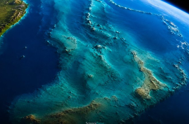
Web Desk: For generations, school maps have taught that Earth has seven continents. But beneath the South Pacific lies a vast geological structure that challenges that familiar picture: Zealandia, or Te Riu-a-Māui, a continent-sized mass of continental crust that is about 94% submerged.
Covering roughly 4.9 million square kilometres, Zealandia is largely hidden beneath the ocean. New Zealand and New Caledonia form some of its most prominent exposed sections, while the rest extends across submerged ridges, plateaus and basins.
Scientists did not suddenly discover the landmass in 2017. Instead, decades of geological and geophysical research gradually established that the underwater region represents a coherent body of continental crust rather than a collection of unrelated islands and fragments.
Geophysicist Bruce Luyendyk proposed the name Zealandia in 1995. The geological case gained wider attention in 2017, when Nick Mortimer and 10 other researchers published a study arguing that the region met the main criteria used to distinguish a continent.
Their assessment placed Zealandia at approximately 4.9 million square kilometres, with about 94% lying below today’s sea level.
The distinction is important because a continent does not have to be completely dry.
Instead, geologists examine the character, thickness and continuity of the Earth’s crust. Continental crust is generally thicker, less dense and more compositionally diverse than the basalt-rich crust underlying the deep ocean.
Scientists used four broad characteristics to assess Zealandia: its elevation relative to the surrounding ocean floor, distinctive geological composition, continental-type crust and substantial, clearly defined area.
The evidence supported all four.
Rock samples collected from submerged areas include granite, greywacke and schist, materials associated with continental geology. Geological belts exposed in New Zealand and New Caledonia can also be traced into the submerged regions.
Seismic measurements provide another important clue. Zealandia’s crust generally measures between about 10 and 30 kilometres thick, with some sections beneath New Zealand’s South Island exceeding 40 kilometres.
Although the crust became unusually thin after being stretched during its separation from Gondwana, researchers say it remains fundamentally different from ordinary oceanic crust.
Gravity measurements, seismic data and maps of the ocean floor further help identify the boundaries between Zealandia and the surrounding oceanic crust.
For much of modern history, Zealandia’s geological identity remained difficult to establish because most of it sits underwater.
Scientists had to assemble evidence from multiple sources, including dredged rock samples, seismic measurements, magnetic anomalies, gravity data and detailed maps of the seafloor.
A 2023 study published in Tectonics added to the evidence by examining rocks and magnetic patterns across northern Zealandia. Researchers identified geological features including ancient granitic structures, sedimentary basins and volcanic rocks extending through the submerged region.
That work followed years of research aimed at connecting individual geological features into a single continental structure.
GNS Science later described the broader mapping effort as the first geological mapping of a continent to its underwater edges at reconnaissance scale.
However, reconnaissance mapping does not mean scientists have physically sampled every part of the enormous region. Instead, researchers combined available geological and geophysical evidence to establish the larger structure.
The apparent absence of Zealandia from school atlases does not necessarily represent a scientific contradiction.
There is no single worldwide authority that determines an official number of continents. The familiar seven-continent model is largely a geographic and educational convention.
In many English-speaking countries, Europe and Asia are treated separately, producing seven continents. Other systems combine them into Eurasia, while some classifications treat North and South America as a single continent.
Geologists, meanwhile, classify large crustal structures according to their physical characteristics rather than political borders, population or whether most of the surface is above sea level.
Therefore, describing Zealandia as an eighth continent works when it is added to the familiar seven-continent classroom model. Under a geological classification that treats Europe and Asia as one continent, Zealandia could instead be considered the seventh geological continent.
The popular description of Zealandia as a continent that “sank” around 85 million years ago oversimplifies a much longer geological process.
The region began separating from the larger Gondwana landmass roughly 105 million to 85 million years ago. Tectonic forces gradually stretched and thinned its crust before seafloor spreading opened the Tasman Sea.
The process continued as tectonic activity fractured, tilted, raised and lowered different sections of the region.
About 85 million years ago marks an important stage in that broader separation rather than a single moment when an intact continent suddenly disappeared beneath the ocean.
Zealandia also remains geologically active. It sits across the boundary between the Australian and Pacific plates, while earthquakes, faults and mountain building in and around New Zealand reflect continuing tectonic movement.
Zealandia’s enormous size has also generated some exaggerated comparisons.
At roughly 4.9 million square kilometres, it is about 1.5 times the total area of India, which covers approximately 3.29 million square kilometres.
If compared only with India’s land area, Zealandia is about 1.65 times larger. So claims that it is “nearly twice the size of India” depend on rounding and the measurement being used.
A more precise comparison is that Zealandia covers roughly two-thirds of Australia’s area.
Even with that qualification, its scale is extraordinary. Researchers have argued that its size and geological coherence make “continent” a more appropriate description than terms such as microcontinent or continental fragment.
The story of Zealandia is therefore less about scientists discovering a mysterious new piece of Earth and more about scientists changing how they interpret an old one.
The ridges, islands and underwater plateaus were already known to scientists, sailors and satellite mapping systems. What was less obvious was that they formed a single, coherent continental structure beneath the South Pacific.
As researchers combined geological samples with seismic, magnetic, gravity and bathymetric evidence, the larger picture emerged.
That is also why Zealandia remained absent from ordinary maps for so long. Conventional maps emphasize coastlines and visible land, while geology follows the crust beneath the water.
The continent was not missing from Earth. It was missing from the way people traditionally pictured Earth.
Today, Zealandia stands as a striking reminder that the planet’s geography does not end at the shoreline and that some of its largest structures may be hiding in plain sight beneath the world’s oceans.
Read more: China’s J-36 vs US F-47: Five features that could shape future warfare